Case Studies
North Sea Palaeolandscapes
North Sea Palaeolandscapes is a remarkable project utilizing 3D seismic data to generate models which will be of enormous value to the geological and archaeological community (as well as to the aggregate extraction industry). The University of Birmingham is the lead organisation and other contributing organizations include the University of Southampton, BGS (British Geological Survey), Petroleum Geo-Services, English Heritage, BMAPA (British Marine Aggregate Producers Association), Aggregates Levy Sustainability Fund, TNO (Netherlands Institute of Applied Geoscience) and Tigress. It is funded by Aggregates Levy Sustainability Fund (administered by English Heritage). The project runs from October 2005 - March 2007.
The Project
The British continental shelf contains one of the most detailed and comprehensive records of the Late Quaternary and Holocene landscapes in Europe. This landscape is unique in that it was extensively populated by humans but was rapidly inundated during the Mesolithic as a consequence of rising sea levels as a result of rapid climate change. Previous researchers have recognized the rapid inundation may have preserved topographic features and caches of environmental data of high quality which may be used to provide insights into Holocene landscapes which, if located and sampled, may be unparalleled by terrestrial sites. Knowledge of the development of this landscape is also critical to our understanding of the impact of climate change on palaeobathymetry and shoreline sequences. It is clear that the exploitation of the Southern North Sea for energy and mineral resources, most notably aggregate extraction, remains a strategic goal for the UK and without adequate data this remarkable landscape is under significant threat from development. Furthermore, given that this landscape suffered changes comparable with those predicted for the British shoreline over the next century, the value in providing comparative data for the future impact of global warming seem clear.
|
|
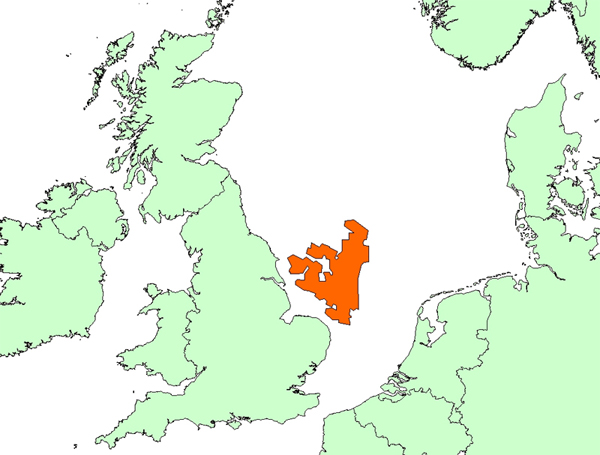
| Figure 1. The extent of the 3D Seismic data currently employed in the project |
The use of 3D seismic data provides an efficient way of generating a regional model for the Late Quaternary and Holocene and an excellent framework for the further integration of shallow borehole, environmental and shallow (high resolution) geophysical data for the purposes of geological and archaeological interpretation. The data can also be used, in conjunction with proxy ecological and archaeological data, to identify deposits with high preservation potential for use in the development of wider mitigation strategies. Palaeo-mapping of the Southern North Sea provides a unique opportunity to provide detailed deposit mapping which can be used in mitigation procedures to explore the impact of aggregate extraction over very large areas and by Aggregate groups to design alternative extraction strategies which minimise destruction to areas with high preservation potential and continue to permit responsible mineral extraction and development.
Current results from research carried out at Birmingham suggest that this methodology significantly enhances results produced using comparative technologies traditionally used to investigate shallow stratigraphic sequences. Whilst the data provided will be extensive, rather than high resolution, the information will place the United Kingdom in a lead international position in respect to the cultural assessment of marine environments as well as with a significant international advantage in the development of mineral exploitation strategies that are profitable, sustainable and environmentally friendly and and place the united Kingdom in a lead international position in respect to the cultural assessment of marine environments.
|
|
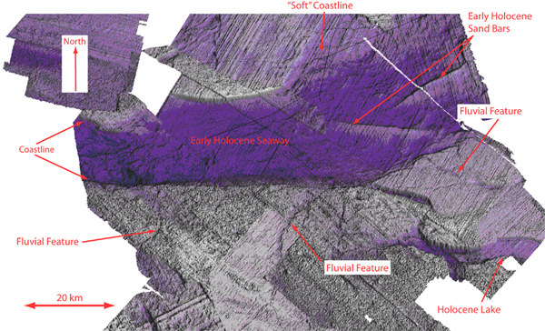
| Figure 2. A model of the Holocene Marine Seaway to the South of Dogger Bank |
The North Sea Palaeolandscapes Project utilises a variety of geophysical data sources, in conjunction with more traditional map data to provide information for the output of this project. The primary Geophysical data set consists of the 3D seismic 'Mega-Survey' as compiled by PGS (www.PGS.com). This is industry standard 3D data acquired using the towed streamers and a variety of seismic sources (primarily airgun). This geophysical dataset is complemented by a suite of High Resolution 2D Seismic lines acquired using boomer and airgun sources. To complement the geophysical data, bathymetric data has been acquired from the BGS, along with a variety of Geological Mapping for the area in traditional forms. 3D Seismic data provided by Petroleum Geo-Services (<http://www.pgs.com/>) 2D Seismic data provided by the British Geological Survey (<http://www.bgs.ac.uk>)
|
|
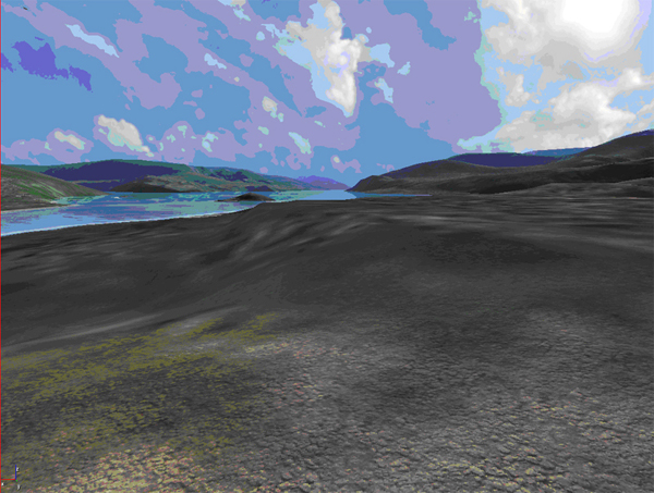
| Figure 3. A Virtual Recreation of the area shown in Figure 2.(Image courtesy of Eugene Ch'ng) |
The project intends to create a variety of resources that can be utilized by both the archaeological community, in the form of academic research and heritage management activities, as well as the extractive industries (such as aggregates, Oil & Gas, Fishing) as planning tool. To achieve this goal an ArcIMS Website (Internet Map) will be created to allow varying degrees of access to the project data dependant on user requirements and data security. The ArcIMS site will allow free access to the interpretation as well as associated mapping. Researchers and organizations requiring more detailed access will be allowed access through a secure portal. Further to this digital and traditional paper maps detailing the likely positions of archaeological resources, their vulnerability and accessibility will be created for use by archaeologists, the interested public, local and national government as well as industry. As a primary academic output, the project has secured an entire issue of the publication 'Archaeological Prospection' to illustrate and promote the work and techniques developed by the project to the archaeological community as a whole.
|
|
| Figure 4. A solid model of one of the Palaeochannels being investigated in 3D through the use of VR technology |
Primary Aims
- To promote the use of data to map the environmental and archaeological potential of the Southern North Sea for developmental purposes
- To use the existing 3D seismic datasets acquired on the United Kingdom continental shelf for exploring Late Quaternary and Holocene geology over the area of the Southern North Sea
- To provide a detailed map of the topographic features of the region and to use voxel rendering to allow the true 3D architecture of Late Quaternary and Holocene systems to be established.
- To integrate the Holocene topographic data with sample core and borehole data to ground truth data and calibrate results
- To provide a model of survival potential for environmental and archaeological deposits within the area of the Southern North Sea which can be used by the aggregate industry and curatorial groups for management purposes
- To introduce aggregate companies to the potential of extensive 3D seismic technologies as a source of data for management of the marine resource
Publications/Further Reading
Ch'ng, E., Stone, R. J. and Arvantis, T. N. 2004. The Shotton River and Mesolithic Dwellings: Recreating the Past from Geo-Seismic Data Sources. The 5th International Symposium on Virtual Reality, Archaeology and Cultural Heritage, VAST (2004), in cooperation with ACM SIGRAPH and The Eurographics Association, 7-10 December, Brussels, Belgium, pp. 125-133, 2004.
Fitch, S., Thomson, K. and Gaffney, V. 2005. Late Pleistocene and Holocene depositional systems and the palaeogeography of the Dogger Bank, North Sea. Quaternary Research. 64, 185-196.
Dedicated volume of Archaeological Prospection (in preparation.)
Tools and Methods
Tools
Tigress 5.0.1 (x86_64 version); RSI Rocksolid Attributes 3.0; Seisee 2.5; OpendTect 2.2.3; Mercury Amira 4.0; Mercury Amira 4.1 (x86_64 version) inc. VLD package; SMT Kingdom 7.6; ArcGIS 9.0; Arcview 3.3; Erdas Imagine 8.7; AVS Express (incorporated within Tigress 5.0.1); Rivex 3.7; Adobe Illustrator CS2; Exceed 11.0; Google Earth.
Method Categories
Data Structuring and Enhancement; Data Analysis; Data Publishing and Dissemination; Practice Led Research; Communication and Collaboration Strategy; and Project Management
Specific Methods
3D seismic modelling, solid modelling, volume and attribute rendering
Data Formats
SEG-Y; Landmark Ascii; Landmark Well Format; GeoTIFF; Erdas Imagine IMG; JPEG; Esri Shapefile; Esri Grid; AutoCAD DXF; Amira Mesh; Amira LDA; Amira Surface file; Ascii Text file.
Metadata Standard
SEG Y rev.1 2002.
Project Website
<http://www.iaa.bham.ac.uk/research/fieldwork_research_themes/projects/North_Sea_Palaeolandscapes/index.htm>
Staff and Advisors
Project Team
- Ms Kate Briggs
- Mr Simon Fitch
- Prof. Vince Gaffney (Principal Investigator)
- Dr Ben Gearey
- Dr Simon Holford
- Dr Andy Howard
- Dr David Smith
- Dr Ken Thomson (Principal Investigator)
Management Committee
- Andrew Bellamy, BMAPA (British Marine Aggregate Producers Association)
- Ingrid Ward, English Heritage
- Virginia Dellino Musgrave, English Heritage
- Justin Dix, University of Southampton
- Huw Edwards PGS (Petroleum Geo Services)
- Nic Flemming, University of Southampton
- Paul Hatton, Information Services, University of Birmingham
- Chris Loader, PGS (Petroleum Geo Services)
- Valerie Scadeng, Mercury
- Paul O'Neil, Tigress
- Ron Yorston, Tigress
AHDS Methods Taxonomy Terms
This item has been catalogued using a discipline and methods taxonomy. Learn more here.
Disciplines
- Archaeology
- Ancient History
Methods
- Data Capture - 2d Scanning/photography
- Data Capture - 3d modelling - vector - volumetric
- Data Capture - Digital remote sensing
- Data Capture - Geophysical survey
- Data Capture - Usage of existing digital data
- Data Analysis - Data mining
- Data Structuring and enhancement - Geo-referencing/projection
- Data Structuring and enhancement - Graphical rendering
- Data Structuring and enhancement - Image enhancement
- Practice-led Research - 3d modelling - vector
- Practice-led Research - Virtual world modelling